 |
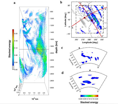
The Sloazvis
model on the left of the figure shows seismic reflections
estimated within a 3D volume. The volume represents an area of
approx. 3000 km x 3000 km and a depth of 3000 km beneath the
Caribbean. The colours represent energy, and a quadratic opacity
function is employed by the software to render the lower energies
more transparent. The figure (b) shows where the cross-section views
in (c) and (d) were taken from.
The reflections show evidence of a
slab and joint interpretation of the waveform modelling and
geodynamical considerations suggests processes and structures at the
top and bottom of Earth's mantle are linked by large scale flow,
which supports the idea of whole mantle convection. |