|
|
|
Objectives |
Methodology |
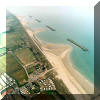
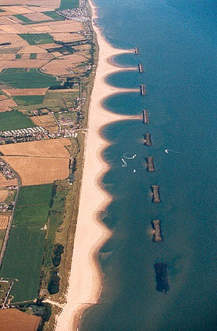
The study area of LEACOAST2 will be
extended from the current LEACOAST
project to cover a 6km-long stretch of
coastline, consisting of four
sub-regions:
- an up-drift zone from Cart Gap
to the first breakwater,
- the 4 segmented shore-parallel
breakwaters (SSPB) of Phase 1,
- the 5 lower SSPBs of Phase 2,
and
- the down-drift zone as far as
Horsey. On a time-scale of months to
years the SSPBs cannot be viewed in
isolation from the beaches up- and
down-drift.
In order to study sediment pathway,
and interactions between the structures
and tides/waves on longer temporal and
wider spatial scales, the project will
combine the process-based computer
models developed in UL with additional
physical processes, the existing UEA
engineering level model and the
probabilistic approaches via 1 to n-line
models developed by researchers in the
School of Engineering at University of
Plymouth (UP) and incorporate the
advanced new acoustic, radar and video
monitoring equipment into a new field
programme together with nearshore point
measurements and frequent beach and
nearshore bathymetric surveys.
Numerical Models
- Phase-resolving process-based
Q3D model
- Wave period- averaged 2D model
- Probabilistic engineering 1-N
line model
- Empirical Orthogonal Eigen
Functions (E.O.F.) based model (for
long-term effect ~10 years
prdictions)
Field Measurements
- Rapid GPS bathymetric survey
- ADV/ADCP nearshore measurements
- Agrus 5-camera video system
- X-band radar
- Stable/Blisst offshore
measurements
- Side-scanner for bedforms
Data Management
- BODC data analysis and archive
|
|
|
 |
|
Sea Palling, Norfolk |
Links:
|
|
|