Multiple Pressures On Africa's Third Longest
River
By Emmanuel Obot
A
combination of human population growth, unsustainable development,
and desertification, are threatening the river Niger's ability to
maintain essential food and water supplies to local people. River
flows in the basin are decreasing at the same time as fishing
pressure is increasing, leading to drastic declines in fishery
yields. Deforestation and farming of fragile soils is leading to
siltation of river channels. Other pressures come from dam building
and the highly invasive water hyacinth, introduced from Latin
America.
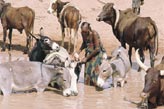
The ancient city of Bussa once stretched linearly along the River
Niger, its name derived from ancient travelers and traders. Today,
Dogo'n garri ("long city" in the Hausa language) lies sunk in Lake
Kainji, in Nigeria. It is immersed with the rich alluvial flood
plains of the River Niger, which supported dry-season arable
cropping, while the lush stands of White Burugu (Echinochloa
pyramidalis) provided dry-season grazing for nomadic and resident
livestock.
 |
|
© WWF-Newby
Niger
|
|
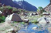
The third longest river in
Africa (after the Nile and the Congo), the River Niger rises from
the Fouta Djallon highlands near the Sierra Leone -Guinea border.
Known as Jobila in Mali and Kwara within Nigeria and flowing
northeast through Mali then southeast into Nigeria, the Niger is
roughly 4,200km long with a catchment area of 1.25 m sq km.
Along its course, the upper Niger approaches the southern tip of
the Sahara desert around Timbuktu, where it separates into several
braided arms to form an extensive inland delta.
Monsoon rains fall between May and September at the headwaters of
the Niger. The water from these events produces a surge that expands
the inland delta to as much as 25,000 sq km but which shrinks to
4,000 sq km in dry periods.
The semi-arid region around Timbuktu receives very little
rainfall. This surge is therefore, an important lifeline for the
local people. The surge is dissipated in the inland delta, and clear
water leaves the delta to flow towards Nigeria arriving in Kainji
(as the familiar Kainji peak floods of January to March) 6 months
later. This flood of clear water is known as the "black flood". It
is distinguished from the "white floods", which are silt-laden
floodwaters originating from rainfall in the catchment of the River
Sokoto and its tributaries (April to September). This flood arrives
in Kainji in September and cascades down the Niger recharging
numerous floodplain wetlands until it is discharged into the Gulf of
Guinea in the coastal Niger delta: this huge delta (32,260sq km) is
a complex of mangrove-dominated wetland made up of river
floodplains, tidal floodplains and chains of barrier islands.
|
 |
|
© WWF/J
Newby
Niger
|
The two major
floods - the black flood and the white flood - influenced the rhythm
of life of human, livestock and wildlife populations resident in the
River Niger floodplain. The people of Dogo'n garri, the inner
savanna and semi-arid lands of Mali, through millennia of
association with the flood rhythm of the Niger developed a fadama
agricultural system producing two crops in the year; one in the
rainy season by rain-fed methods and the other using residual
moisture from receding floods during the dry season.
Livestock - grazed flood - recession pastures and Palaearctic
birds found ideal wintering and passage conditions for migration.
Fishermen understood and benefited from the local breeding migration
(during the white flood) of various economically important fish. In
the lower reaches and in addition to fishing, large transport and
goods-ferrying vessels would go up to Lokoja at the confluence of
the Niger and River Benue with goods to be traded in Kaduna, Kano
and Niger Republic. In 1968 however, the Kainji dam was built
resulting in a water impoundment of 13,000sq km, called Lake Kainji.
The dam displaced 44,000 people and a variety of wildlife species.
Most of the people were resettled in New Bussa. For terrestrial
wildlife species, the Kainji Lake National Park served as a refuge.
Aquatic species such as hippopotamus (Hippopotamus amphibius) and
the local manatee (Trichechus senegalensis) died out probably due to
the disappearance of aquatic macrophytes from their habitat in the
early years of the lake. Poaching by migrant tribes caused the
disappearance of crocodiles and giant tortoises. The development of
a distinctive macrophytic flora of Red Burugu (Echinochloa
stagnina), in association with False Burugu (Vossia cuspidata) and
the floating Sacciolepis africana in Lake Kainji during the late
1980s occurred at a time when schools of hippopotamus were sighted.
However, the optimism of conservationists that the manatee would
return, because of aquatic macrophytes in the lake, has not yet been
realized. The recent invasion of the lake by the water hyacinth
(Echhorinia crassipes) is not encouraging.
Next
>